
Navigate:
Home | Properties
| Thetis Island | Strata
Overview | Conservation Covs. | Contact
Us | Links |
Site Guide/help |
Search |
Nav.
help (pop up) | Greenquest Page
navigation index | You are at our Greenquest page.
Greenquest planning at Meadow Valley Properties.
Greenquest is a term describing our search
for appropriate, environmentally sensitive, land use based on an understanding
of the land.
Objectives of our land use plan
- Minimize long term negative environmental and aesthetic impact on our
site in relation to traditional development practices.
- To provide tranquil pastoral home sites and land for recreation and
human enjoyment of nature and natural resources.
- Maximize and enhance the biodiversity of the area.
Within our three objectives certain themes influenced our land
use planning and the type of lots that we needed to produce. These factors that we sought to emphasize and that we felt
were likely to be priorities for those seeking property on Thetis were:
 Views, sunshine, natural beauty, access to waterfront, tranquility,
a rural lifestyle, gardening, outdoor recreation - both land and water based,
family life, cottage/cabin retreats, retirement and, by inference, the privacy
necessary to enjoy these benefits.
Views, sunshine, natural beauty, access to waterfront, tranquility,
a rural lifestyle, gardening, outdoor recreation - both land and water based,
family life, cottage/cabin retreats, retirement and, by inference, the privacy
necessary to enjoy these benefits.
We have planned the land use in Meadow Valley to achieve these
objectives and address these themes. Our strata plan was based on detailed
study of the land involved and a familiarity of many years living on that land.
In the latter stages of our planning process a widely experienced landscape
architect, Michael Bocking, helped us to pull our ideas together into a
presentation of the plan.
Our land use plan addresses our Greenquest philosophy. It provides
properties of distinction with significant infrastructure in a beautiful
setting, we know that these properties will meet the priorities of those
seeking a place on Thetis.
Below you can read about how we went about the planning process and view
some images of the plan.
Drawings of the planning process.
The sections, listed below, about our planning have thumbnails with
links to drawings (by Michael Bocking) representing the history of the various
plan stages.
There are four drawings:
- Landscape Analysis
- House sites, access and servicing
- Land Use Plan
- Birds Eye View artists impression of the project as it will look when
finished.
Follow those thumbnail links, below, for individual drawings, or follow
this link, which will open a new window with a
page with all the drawings
and a large scale plan drawing of meadow Valley. To be able to see details on
the drawings, the images must be large--this is why we have separated them. We
suggest using the links that open them in a new browser window, as this will
allow having them there for reference to the text--unless you are using a multi
pane browser. The images will take a while to load if you have a slow
connection, so please just keep reading while they do (another advantage of
using a new window or multipane browser).
This sub-section is repeated in condensed form on our
"Properties" page.
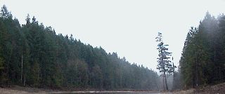
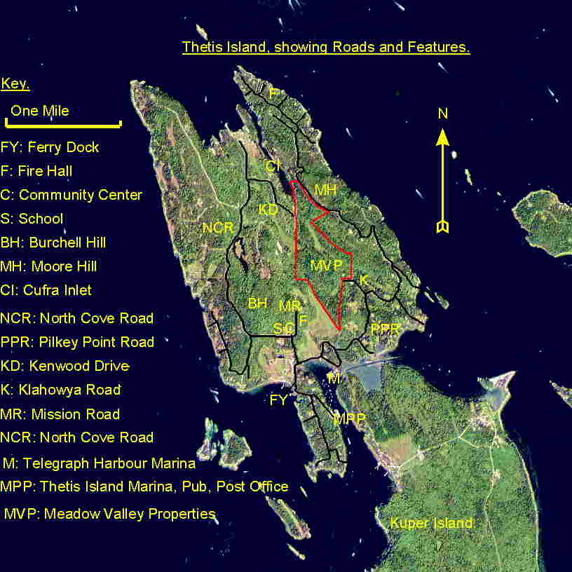
The Meadow Valley is at the center of Thetis Island, stretching from the
picturesque southern edge “Old Coast” Bluff overlooking grazing lands
and meadows near to Pilkey Point Road in the south about a mile to waterfront
on ecologically important Cufra Inlet at the North. Our 206 acre site extends
the length of this valley and forms a large part of it's watershed, providing
an integrated management unit for our Strata. The image, below, shows Meadow
Valley in relation to Thetis and will provide you with the locations of roads,
etc. Please see "Detail
Map" images page for a better quality image. Scroll down below the
image for further details.
Meadow Valley, Thetis
Island.
Index.
Thetis Island (for details see our "Thetis Island" page) is situated
centrally in the Pacific Northwest Coastal region, the region termed
"Cascadia", Thetis has the characteristics of that bioregion, a climate with a
mediterranean combination of mild winters and warm, dry summers support a
unique ecosystem and provide an ideal environment for gardening and outdoor
recreation. Thetis Island is in the rain shadow of Vancouver Island, having an
annual rainfall of about 850 mm (33 inches) - far dryer than Vancouver or
Seattle. This climate is common to the Southern Gulf Islands, and the Saanich
peninsula/Victoria (B.C.) area, supporting the unique arbutus/Garry Oak
ecosystem as well as endearing the area to gardeners and those escaping the
wetter climes of Vancouver and Seattle. As a small island, Thetis has
proportionally more waterfront/foreshore ecosystem and more moderating effect
from the ocean. In terms of human geography, Thetis is relatively undiscovered
and undeveloped, with an atmosphere of rural seclusion and tranquility,
although it has remarkably good connectivity to major centers.
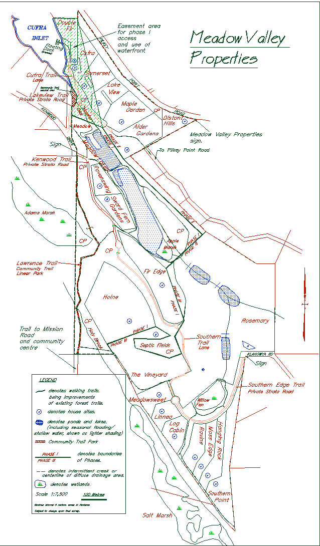
The main feature of the property is the Meadow valley which extends
south from Cufra Inlet. A large marsh (Apple Marsh), small fen (Willow Fen),
and a seasonal stream (Meadow Creek) flowing from Willow Fen at the south
through Apple Marsh to Cufra Inlet at the north occupy the valley. The property
forms a large part of the watershed of the Meadow Creek. From a narrow bench
above Cufra Inlet, the land rises sharply east up to Pilkey Point Road. To the
west and southwest of Apple Marsh, the land rises more gradually up to two low
hills. South and southwest of Willow Fen the ground rises to the southern edge
of the property where it falls abruptly away over bluffs, the base of which
define the boundary. From the top of the bluffs one looks over an agricultural
valley and salt marsh toward Vancouver Island in the west. Sandstone bluffs
associated with steep slopes provide opportunities for views in several areas
of the site.
Cedar groves surround a creek drainage and marsh along the west boundary
of the property. The majority of the site is heavily wooded with Douglas Fir,
mixed with Balsam Fir, Alder, Maple, and Cedar in low areas, and with Arbutus
on upper slopes. The property has been selectively logged in the past, the last
time for the majority being about 70 years ago. Several large specimen Douglas
firs and maples are found on the property. Open grass fields are situated
northwest of the marsh and near the southeast property boundary, in an area
which was formerly used for sheep farming.
Index.
Casual observation of the site since 1984 was augmented with more
detailed survey and site investigation using consultants (Hydrogeological,
Geotechnical, Engineering and a Biology) and recorded information and resource
maps.
Through these methods we identified "resource" or "sensitive" areas (wet
areas, steep slopes, vegetation features to be protected, wildlife habitat,
biodiversity enhancement opportunities), suitable areas for water supply and
enhancement of water resources, for sewage disposal, areas suitable for
agriculture and gardening and areas suitable for residential use. See also the
above site description.

To see a drawing representing the conclusions of our
landscape analysis, please follow this link which will open the drawing in a new
window for easy reference.
If you don't want to use a new window, follow
this link.
Survey information and digitized mapping data were used to form an
appreciation of the landforms and the distribution of land types. This
information combined to present a "land capability classification" which, as
the beginning of the land use plan, underpinned further planning decisions.
Index.
A search of the property was made to identify potential house sites.
From 35 possible sites, 20 house sites were selected, and an equal number of
accessory cabin sites were located. This number is based on the site's R-2
zoning, which allows one house and one cabin per 10 acres.
Criteria for site selection included accessibility, privacy from
neighbors, views, land suitability and type and degree of natural light (with a
strong priority given to southern or southwestern exposure). Care was taken to
avoid feature trees and sensitive areas. The result is a variety of forested
and open sites with good views and solar exposure.

To see a drawing representing an
overview of our exploration of potential house sites, access and servicing
planning process, please follow this
link which will open the drawing in a new window for easy reference.
If
you don't want to use a new window, follow this
link.
House sites tend to be gathered in the north and southwest parts of the
property, leaving much of the central area as common greenspace and for large
lots. In the case of some lots house sites will be fixed by the use of a
building scheme to ensure privacy for neighbors, view corridors, etc..
Index.
Access to the property is from Kenwood Drive in the northwest and Klahowya
Road in the south. Pilkey Point Road forms the northeastern boundary and services
one house site (Distant Hills, lot 7). A dedicated road allowance extends from
the end of Mission Road to the southwest corner of the site, an existing trail
follows the approximate line of this dedication. A number of old and overgrown
pioneer forest access roadways pre-existed on the site. Where feasible, new
roads and driveways are designed to follow these existing routes. Many of the
remaining old overgrown forest access roadways provide the basis of an internal
walking trail network.
A conventional subdivision would result in public roads, to be built to
a 50-km/hour highway standard (wider and straighter) as well as the provision
of a public through connection of Kenwood Drive and Klahowya Road. The latter
would increase through traffic on neighboring roads, with the subsequent impact
on the privacy and safety of residents. Potential road impact on the
environment, aesthetics and privacy was one of the deciding factors in choosing
a Strata model for the development (see below).
Access roads in the proposed bare-land strata subdivision will be
privately owned and maintained and will be narrow and gravel surfaced, with a
design speed of 30 km/hour. Kenwood Drive and Klahowya Road are not proposed to
be joined, except by a gated service lane. This will increase privacy and
security for owners and avoid impacting present residents on theses roads with
through traffic.
Index.
To see a drawing ( same drawing
as referenced in the "House Site" section, above) representing an overview
of our exploration of potential house sites, access and servicing planning
process, please follow this link
which will open the drawing in a new window for easy reference.
If you don't
want to use a new window, follow this link.
Domestic water supply.
Suitable locations for wells were determined and wells drilled and tested,
domestic water will be available to all residences from drilled wells each serving
one to four lots. After changes to regulations individual wells were then drilled
for each phase one lot. Wells were tested and a hydrogeological investigation
was undertaken of their capacity and drawdown characteristics. All wells are
minimum 1000 feet from any septic field, to Ministry of Environment standards
(This contrasts to the normal Ministry of Health 100 foot separation requirement
in normal rural subdivisions).
A secondary water system draws water for irrigation needs (of the individual
lots and the common areas) and fire suppression from the constructed Meadow
Valley lakes located in the north part of the site. This reduces impact on groundwater
resources. Each house will be connected to a centrally located sewage treatment
plant via the installed collector mains.
Freshwater resource enhancement.
For the amenity and biodiversity value of open freshwater, and to
provide irrigation water for lots owners (thus reducing groundwater impact) and
to provide water for fire suppression, a system of five lakes and ponds is part
of the Meadow Valley plan. This storage will enhance the water resources and
biodiversity of the Meadow Valley, whilst at the same time the secondary water
system has been designed to extend rather than degrade natural wetland areas.
This water source and storage system together with a pumping station and piping
to each lot have been constructed under an approved water license.
Water is at a premium on the Gulf Islands and open freshwater of any
substantial area is very rare on the smaller Islands, the open water ecosystem
provided by the lakes will greatly enhanced the biodiversity of the Valley.
Sewage treatment.
It was decided to reduce impact and to increase flexibility in land use
by using a high quality community sewage treatment system. Traditional sewage
disposal by individual septic fields is problematic in many areas in the Gulf
Islands. It is often high impact - impact from clearing for the fields and from
groundwater pollution. Moreover, the location and feasibility of individual
septic fields can severely restrict decisions on lot layout and land use.
The Meadow Valley Properties system was designed using a secondary
treatment plant to produce high-quality effluent which will be disposed of via
a common septic field. This system was designed under stringent Ministry of
Environment guidelines. Selection of a suitable disposal field included
detailed hydrogeological modelling to ensure that we would not be producing
groundwater pollution or other contamination and that the system would have a
long life. Normal rural subdivisions follow the less stringent Ministry of
Health guidelines for private septic systems.
This system, the first of its kind to be used in a development on Thetis
Island (but widely used in BC), is very simple and designed to be highly
reliable and to keep maintenance costs low. The system has been designed for
flow rates high enough to avoid any restriction on numbers of bedrooms in lot
owner's houses and cabins.
Sewage disposal is often a problem for purchasers of unserviced lots on
the Gulf Islands, and this system is also intended to remove this area of
concern for purchasers. The field area itself is about half the size 20
individual fields would be, thus reducing the clearing impact of the
development. The field area is within common property and will provide an
attractive meadow as a common amenity.
Hydro and Telephone.
Despite the natural beauty of the Gulf islands, most developments, for
cost reasons, install above ground Hydro lines, making an ugly visual impact on
many otherwise natural vistas, and mandating clearing and treecutting in the
future for maintenance.
Underground lines are more expensive, but we will be using them in critical
areas, for phase two and part of phase three, to reduce visual impact, improve
reliability and to allow natural regrowth to go undisturbed. This will be a
first on Thetis.
Index.
Capability for wildfire suppression is of importance on the dry Gulf
Islands. Most normal rural residential developments are very vulnerable to
wildfire, since few provisions have been made for control, suppression or
access.
Access and provision of water are also important factors in reducing the
risk of impact from house fires. Few rural developments provide standpipes for
fire suppression water.
Meadow Valley's use of a Strata model and a landscape based planning
process help to make planning for fire control and suppression easier. This
planning includes proper access provisions, contingency plans for fire breaks
and assembly areas and water provision. Our fire control and emergency
provisions planning is more advanced than any current or past development on
the Gulf Islands. This planning has been done in cooperation with the Thetis
Island Volunteer Fire Department.
Meadow Valley is the first development on Thetis Island to have its own fire
suppression water supply. This supply, based around the secondary water system,
includes standpipes strategically located on the access roads and service lane
and a 200 gallon per minute pump system (installed for phase one) with (for
phase two) a 6000 gallon secondary storage system (other than the millions of
gallons stored in the lakes) and 4 inch mainline piping. Access roads and driveways
have also been planned to address fire suppression and emergency access concerns.
Index.
As information was gathered and collated, a land use plan based upon our
objectives and themes and the resource information evolved. The evolving plan
guided design and engineering, and those specific elements then fed back into
revision and fine tuning of the plan.
This plan addresses our greenquest philosophy. It
provides properties of distinction with significant infrastructure in a
beautiful setting, we know that these properties will meet the
priorities of those seeking a place on Thetis.

To see a drawing representing an overview of our
land use plan, please follow this
link which will open the drawing in a new window for easy reference.
If
you don't want to use a new window, follow this
link.
After considering the above factors, and based upon the land use plan,
various lot layouts were drawn. Lot boundaries were defined in the field so
that they would fit the land. In a conventional subdivision, the entire
property would be utilized for residential lots and public roads with "a road
down the middle and lots off either side". This approach, while cheaper and
easier, certainly did not fit in with our objectives.
After consideration of options a Bare Land Strata plan approach was
clearly the most sensible. The image, below, shows the final layout, with the
common areas shaded for easy reference. Description of the plan continues below
the image.
Plan image showing all lots.
Scroll down below the plan for more details.
For more detailed plans please see our
"detail plans" page,
or, for a larger scale plan plus all the planning history drawings, follow
this link.
The strata model was best able to meet our objectives whilst still
providing owners with their own private lots and addressing our themes. See our
"strata" page for details.
In the proposed strata subdivision, lots are configured according to the landscape
suitability. Wetlands, vegetation features, and the inlet shoreline are excluded
from residential lots, and lot boundaries, therefore, conform more to natural
features boundaries. Two groups of smaller lots are gathered in the north and
south areas of the property, and larger lots and common property dominate the
central portion. The 20-lot layout recognizes the need for diversity in terms
of lot size, landscape types, and preference for views, sun, and privacy from
neighbors.
Larger lots contiguous with extensive common property both encourage
the retention of natural habitat in areas large enough to be useful, provides
for wildlife corridors and retains the amenity of greenspace. Together, larger
(over ten acres) lots and common property cover about 149 acres of the 206 acre
site, or 72% of the area. There are three large lots, one of which is about 50
acres. Common property covers about 75 acres, or 36% of the total area.
To maintain privacy and residential standards, house sites will be specified
for each lot after discussion with initial purchasers and some covenanted areas
protect important natural areas or views/privacy strips. Building design guidelines
for a few lots protect common or neighbor's views. Strata regulations are anticipated
to define areas for resident's firewood harvesting.

To see a drawing representing an artists impression of what
a birds eye view of the project will look like when finished, please follow
this link which will open the
drawing in a new window for easy reference.
If you don't want to use a new
window, follow this link.
Index.
The extensive common property allows us to plan for and provide many
facilities and amenities that we could never have considered in a fee simple
model. It allows for integrated fire and emergency planning and for future
maintenance of fire suppression provisions. It also allows for integrated
planning of use of sensitive areas that would otherwise have been cut up into a
number of separate lots.
Approximately 72 acres, or 35% of the property will be retained as common greenspace.
These areas serve a number of functions, including:
- The preservation of wildlife habitat and corridors
- The development of a trail network
- The protection of special vegetation features
- The retention of fresh water bodies and the ocean shoreline as common
areas
- The creation of open spaces for recreation and gardens
- The maintenance of woodlots for the use of residents
- The designation of utility and service access corridors
- The buffering of adjacent properties and roads.
Large lots in the centre of the property contribute significantly to the protection
of natural areas in a similar way that the common areas do, and easements across
some properties will permit lane and trail access and utilities to cross private
land, for the benefit of all residents and the reduction of impact. See Land
Use Plan drawing.
In order to ensure the continuing protection of the environmental values of
particularly sensitive or valuable common property areas we utilized conservation
covenants. Of the 72 Acres of common property about 22 Acres are or will be
protected by conservation covenants. See our "Conservation
Cov." page for details.
The common areas as proposed serve to enhance the use, enjoyment, and
preservation of the property for all 20 lot owners, and to demonstrate
responsible land stewardship.
Common facilities are outlined on the "Strata overview" page.
Index.
The development is expected to be completed within five years, in three
phases.
Index.
Planning and land use regulation on Thetis Island is the responsibility
of the Islands Trust, a body established by the provincial government to
"preserve and protect" the unique environment of the Gulf Islands for their
residents and for the people of B.C.. Building regulation (i.e. the application
of the building code) and other municipal responsibilities fall to the Cowichan
Valley Regional District.
The O.C.P. is a document developed by the Islands Trust Local Trust
Committee after input from the Island community stating general objectives and
policies for land use in the community and which sets the principles upon which
the Land Use Bylaw is built. "The plan offers the community's vision of the
future and proposes a level of acceptable growth."
The Land Use Bylaw for Thetis Island (Islands Trust Land Use Bylaw No.
56, 1997) is a document developed and managed by the Local Trust Committee to
implement, where possible, the principles and objectives of the O.C.P.. Among
other things, it regulates the density of development, creates zones for
different land use and specifies the type of uses permitted on land in a
particular zone.
Meadow Valley Properties is in the R-2, rural residential zone. This
zone has an allowable density of one residence and one guest cabin per 10
acres. In a Strata development this density is averaged as outlined above.
The general uses permitted in R-2 are:
- Dwelling units
- Guest Cottages (max. 700 sq. feet.) on lots 2 acres and over in area
(all Meadow Valley Property lots are over 2 acres and the community sewage
system is designed for house and cabin on each lot).
- Home occupations
- Agriculture
- Buildings and structures accessory to the uses permitted.
- The bylaw also regulates the size and siting and use of buildings and
structures.
Follow the links on our "Links" page to a full copy of the
bylaw and O.C.P., or contact the Islands Trust in Victoria.
Throughout the planning process we made every effort to fall in line
with the community's desires as expressed in these Bylaws and the O.C.P..
Fortunately, the priorities of our plan are very much in line with the
"preserve and protect" mandate of the Islands Trust. The Meadow Valley
Properties plan is considered to be a model for appropriate development,
consistent with the OCP and land Use Bylaw.
We maintained two way communication with the community during the planning
process. Our plan has many advantages for the Island in comparison to a more
traditional development, for example the reduction of road impact, the community
park trail and the use of covenanted buffer strips. The fire provisions were
also developed in consultation with the local Fire Department in such a way
as to benefit the whole community.
As part of our plan a community trail park equivalent has been donated by us
to the Thetis Island Residents and Ratepayers Association (TIRRA) for the use
of community members, see our
"community trail" page for details.
This link is to a page with some
of these benefits outlined. The page contains a link back to this section.
Index.
Meadow Valley Properties.
For information on our property and to view our lots for sale
please see our "Properties"
page.
Other.
We will frequently update and enhance our website, so check back often.
We are happy to respond promptly to any specific question, just e-mail us.
Top
Contact us
Please contact us for more information on our properties and on Thetis
Island.
Email us at info@trax.bc.ca or
call 250-246-4774
Meadow Valley Properties, quality planned real estate by Trax Developments Ltd., Box 9-6, Thetis Island, B.C., V0R 2Y0, Canada.
Navigate; you are at our Greenquest page, click on the following links
to visit other parts of our site: Home, Meadow Valley Properties, acreages for sale.
| Our real estate, lots for sale | Thetis
Island, Southern Gulf Islands | Conservation
Covs. | community trail
| Strata Overview | Contact
Us | Trax Developments, Company|
Photo Images |
Site Guide/help | Search
| Nav.
help (pop up) |
Links |